Anonymous
6/21/2025, 9:05:16 PM No.63873638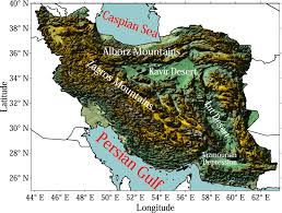
Iran's topography is characterized by a rugged, mountainous rim surrounding high interior basins. The main mountain ranges are the Zagros, which bisect the country from northwest to southeast, and the Alborz, which runs along the Caspian Sea's southern coast. The interior is largely a central plateau with two significant salt deserts: Dasht-e Kavir and Dasht-e Lut.
Detailed Breakdown:
Zagros Mountains:
These mountains form a series of parallel ridges interspersed with plains, extending from northwest to southeast. Many peaks exceed 3,000 meters (9,843 ft) with some reaching over 4,000 meters (13,123 ft) in the south-central region.
Detailed Breakdown:
Zagros Mountains:
These mountains form a series of parallel ridges interspersed with plains, extending from northwest to southeast. Many peaks exceed 3,000 meters (9,843 ft) with some reaching over 4,000 meters (13,123 ft) in the south-central region.
Replies: