Search Results

7/17/2025, 5:50:05 AM
Since the images from the satellites are long strips, they are stitched together and then modeled onto a sphere before the image is created
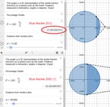
The Blue Marble 2012 image is a near-sided perspective projection, with a viewing point of 2,100 km above the surface
This projection results in a very wide-angle presentation such as one might get with a fish-eye lens, and it does not include the whole hemisphere
At that distance, the visible portion of the sphere is only 12.4% which matches what we see in the image
I cannot find any source on the projection used for the Blue Marble 2002
A geostationary orbit is 36,000 km
That seems to roughly fit the image, and would be a logical choice
>Blue Marble 2012 Source
https://en.wikipedia.org/wiki/The_Blue_Marble#Blue_Marble_2012
>Visible fraction calculator
https://www.desmos.com/calculator/jyjoxgf11i
Page 1