Search Results

7/18/2025, 8:05:45 AM
I'm not a flatearther. If I had to guess flatearth is a well-poisoning red herring designed to trivialize a legitimate concern: why are there so few high quality satellite photos of the poles?
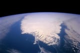
I tried finding satellite photos of Greenland out of curiosity. Apparently the ice sheet is over 3000 meters thick there, and I thought it would be cool to see. Greenland is the worlds 12th largest landmass at 2.2m square kilometers. And yet, pic related is the best real satellite photo that I could find of the entire landmass. The best picture we have is this? Seriously? It isn't even the entire landmass, and it is taken at a weird angle where the northern extremes are shrouded.
If there's nothing to hide, why is it so difficult to find these pictures? I sense that there is something there that is extremely visibly obvious and would raise questions and ideas the contradict established narratives. I'm not saying I know exactly what is there but there has to be something, there is no way in 2024 with 10,000 satellites in orbit that this is the only picture I can find of such a gigantic landmass.
The excuses as to why there aren't good pictures don't make any sense either.
>It's too expensive to send satellites there
What? The military obviously already has these images, so what could possibly be the strategic or national security imperative preventing them from being released to the public. Also, you would think some kind of private or public science/research/conservation organization would have the means to acquire these photos for scientific study, why haven't they released it? Claiming financial barriers is absurd
Something isn't adding up here and I don't think it's flatearth
Page 1