Search Results
1/26/2025, 9:54:13 PM
>>1944390
Probably because it'd be a pain to code and figure out how to visually represent and give it a clear gameplay value.
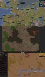
Height on the campaign map is represented by impassable mountains.
That and access to Sweetwater determines the fertility of an area. Tundras, Deserts, and Steppes which have less fertile lands will appear on the right side of mountains (against the world's rotation), in places without sweet water), and more commonly in Hot or Cold regions in contrast with temperate regions.
Mineral resources like deposits of metal, gems and coal will be generated near these mountains.
On the city map these resources often spawn near cliffs or inside mountains and mountain caves.
For city-building, height is represented and comes into play in the form of Fortifications (castle walls) which troops can climb using stairs to give ranged troops an accuracy and range advantage.
If you wanna build "underground" this is made by digging into a mountain or building inside of the naturally ocurring caves.
Other than that houses can get cellars/basements and attic upgrades represented as 1x1 stairs and trapdoors to increase their size/pop capacity.
This is all the Z-Level simulation you need in a game like this.
It's not an isometric game like Stronghold where height can be easily represented visually.
If you just want a Top-Down city-builder with Z-Levels you can just play Dwarf Fortress, but DF can't simulate tens of thousands of citizens/soldiers in a single map like SoS does, precisecely because it also has to calculate for things like Z-Levels and how the physics of water and other entities behave on them.
Probably because it'd be a pain to code and figure out how to visually represent and give it a clear gameplay value.
Height on the campaign map is represented by impassable mountains.
That and access to Sweetwater determines the fertility of an area. Tundras, Deserts, and Steppes which have less fertile lands will appear on the right side of mountains (against the world's rotation), in places without sweet water), and more commonly in Hot or Cold regions in contrast with temperate regions.
Mineral resources like deposits of metal, gems and coal will be generated near these mountains.
On the city map these resources often spawn near cliffs or inside mountains and mountain caves.
For city-building, height is represented and comes into play in the form of Fortifications (castle walls) which troops can climb using stairs to give ranged troops an accuracy and range advantage.
If you wanna build "underground" this is made by digging into a mountain or building inside of the naturally ocurring caves.
Other than that houses can get cellars/basements and attic upgrades represented as 1x1 stairs and trapdoors to increase their size/pop capacity.
This is all the Z-Level simulation you need in a game like this.
It's not an isometric game like Stronghold where height can be easily represented visually.
If you just want a Top-Down city-builder with Z-Levels you can just play Dwarf Fortress, but DF can't simulate tens of thousands of citizens/soldiers in a single map like SoS does, precisecely because it also has to calculate for things like Z-Levels and how the physics of water and other entities behave on them.
Page 1