Search Results

8/9/2025, 5:22:15 PM
>>512617556
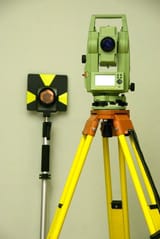
>How the fuck do those things work btw? I think the tripod things are for grade gauging right?
Trimble R12i is a survey grade GPS. Way higher precision that your phone or whatever. I think you're referring to a theodolite/total station.
Those work with trigonometry basically. You set up on a point with known coordinates. Point it at another point with known coordinates to get your starting azimuth. Then when you sight a new point it'll use difference in horizontal and vertical angles, plus the distance with a laser, to calculate the horizontal and vertical coordinates of that new point.
Total stations are more precise than GPS but GPS is usually faster so I try to use that to measure stuff unless it needs to be extra high precision for whatever reason (settlement monitoring, certain types of construction layout, etc)
>But how do you know where you started?
Either establish a new point yourself with GPS or come off a monument with published coordinates.
In Canada the government sets up survey monuments and publishes a database of their coordinates. And all the dimensions of legal plans are referenced to those monuments.
With those old legal plans though they're often not referenced to any monuments or they're super imprecise.
You'd just look for evidence at the lot corners and use those without worrying about the "absolute" coordinates. It's something called "heirarchy of evidence" which is boring and would take a long time to explain lol
Page 1