Search Results
7/8/2025, 6:06:32 PM
>>149314382
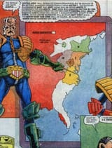
Originally the map covered parts of Canada down to Florida, but most of that got nuked or stomped in the Apocalypse War. They reconciled into the blue area shown in your image (that little nub that's almost detached is the North-West Hab Zone of Sectors 301-305). But as seen in 2000AD Annual 1980, Mega-Miami RIP while it contains some mega-structures also has open beaches and people are bathing in the Atlantic, so it's likely that a lot of natural stuff surviving at this point and the Black Atlantic isn't nearly as irradiated and polluted in the very early strips pre-Apocalypse War (given the number of East-Meg TADs that end up ditching, and the number of MC-1 TADs that are scuttled during that war, it's not totally unreasonable). The west coast of Florida appears to have either been destroyed, abandoned or simply not administrated by MC-1 pre-Apocalypse per this map (another old map shows administration - but not necessarily the city - stretching to the Alabama-Mississippi border).
Current most densely packed city is about 115,000 per square mile; call the original MC-1 (the largest, first and greatest of the Mega-Cities) the blue area plus the two green areas to its north-east and southwest, call that maybe 1/6 of the continental US in area and the area becomes 519,981 square miles; call that home to 800,000,000 and you have 1,538 per square mile originally; but that includes beaches, wide open spaces between blocks, etc. and per the only available maps may or may not include areas beyond the city proper (before Cal built his wall, or Goodman who also had a wall, idk) which were under jurisdiction. It's possible that the current arrangement of munce-farms and other encampments outside MC-1 walls was also made then and included on older maps.
Page 1