Search Results
ID: Oh4pbheg/pol/508255556#508280685
6/22/2025, 5:45:16 AM
>>508280186
>I wouldn't do it unless you knew the people.
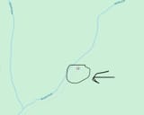
aww its just so pretty from above it looks like a cool holler to explore and at ONE point it actually was a us forest service managed trail
and I did check the 1914ish topo map and it was definitely a railroad at one point (as was big run near spruce knob) cuz in both cases they connect with larger creeks, north fork running down to cass where many lines once connected for western maryland railroad
it just looks like the downstream entrance is narrowly on private land where the road ends :( and the forest service has no idea
I mean WV property viewer is online I suppose you can always find their address and write them a letter but eep
and yeah probably not worth it with all the downed trees
tried that at little black fork - another area where you have a former real trail predeceased by a narrow gauge logging railroad (my favorite!) which flows into shavers fork, and the downed trees were just too crazy
also was trying to see if there was a path there out to baker sods, which looks like on the map it would have a commanding view, but in reality I don't think it does according to info I've found
>I wouldn't do it unless you knew the people.
aww its just so pretty from above it looks like a cool holler to explore and at ONE point it actually was a us forest service managed trail
and I did check the 1914ish topo map and it was definitely a railroad at one point (as was big run near spruce knob) cuz in both cases they connect with larger creeks, north fork running down to cass where many lines once connected for western maryland railroad
it just looks like the downstream entrance is narrowly on private land where the road ends :( and the forest service has no idea
I mean WV property viewer is online I suppose you can always find their address and write them a letter but eep
and yeah probably not worth it with all the downed trees
tried that at little black fork - another area where you have a former real trail predeceased by a narrow gauge logging railroad (my favorite!) which flows into shavers fork, and the downed trees were just too crazy
also was trying to see if there was a path there out to baker sods, which looks like on the map it would have a commanding view, but in reality I don't think it does according to info I've found
Page 1