Search Results

7/3/2025, 2:50:29 PM
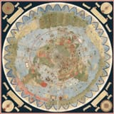
>Urbano Monte made an extremely detailed 1587 world map 10 feet wide
>polar projection (flat earth map)
>north pole at the center surrounded by land and 4 giant rivers
Notably, it depicts islands absent from modern satellite imagery. Think Strava 2018 heat map.
It can be examined at incredible resolution here https://www.davidrumsey.com/blog/2017/11/26/largest-early-world-map-monte-s-10-ft-planisphere-of-1587
ID: TFgL9SEQ/pol/509352202#509354621
7/3/2025, 2:23:58 AM
Page 1