Search Results
6/3/2025, 1:20:26 PM
Did this in the alst thread and didnt get any feedback.
before drawing coastlines and rivers and placing cities, I like to go for very primitive vector maps. Theyre easier to adjust and allow me to gauge distances and shapes better.
What do you think of this one? Too much water? too much land?
The idea is that the separated and at times narrow continents allowed 3 races to develop alongside each other while creating isolated, independently developing subraces of each to form.
The rivers arent representative of where rivers will be, they just mark important wetlands.
I placed some significant features, but they (most likely) arent the only places where those occur. The teal part in the ocean south of the large continent is a very shallow sea with lots of coral reefs.
The dark-green blob in the ocean is a Sargasso-sea style area with kelp so thick it forms swimming islands caught in an ocean gyre.
The red dot in the large continent is a volcanic field.
The grey spot is a salt lake.
The blueisch blobs are huge wetlands. the western one is a mangrove swamp that's passable only on small boats and only with the help/protection of locals
The north pole is a giant boiling volcanic lake encircled by a continuous mountain range.
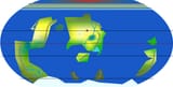
Page 1